Australia on High Alert as Rare Cyclone Targets East Coast in Off-Season Storm Surge
A rare tropical cyclone forming in July threatens Australia’s east coast, with Queensland bracing for impact between July 25 and 26. Unseasonal ocean heat and El Niño blamed.
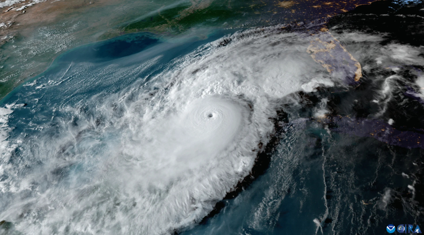
Brisbane, Australia — A rare and intensifying tropical cyclone is forming off the northeastern coast of Australia, poised to strike the Queensland coastline in the coming days. Forecasters are warning that the system, expected to become a severe Category 3 storm, may make landfall between late Friday, July 25, and early Saturday, July 26, 2025. If it does, it will mark the first mid-winter cyclone to hit Australia’s east coast in over 50 years.
The Bureau of Meteorology (BoM) has issued watches and alerts for a large portion of Queensland’s coastline, particularly between Cairns and Rockhampton. As of Wednesday morning, July 23, a low-pressure system in the Coral Sea, located approximately 600 kilometers east of Cairns, is rapidly gaining strength in unusually warm waters.
Officials across Queensland are ramping up emergency preparations, activating cyclone shelters, and urging residents to stock up on essentials. The scale and timing of this event have taken many by surprise, raising serious questions about Australia’s readiness for year-round extreme weather events.
Cyclone Expected to Intensify Over Next 48 Hours
According to BoM forecasts, the tropical low is expected to intensify into a named cyclone by Thursday afternoon, July 24, before approaching the coastline with severe intensity. Current models show the storm reaching Category 3 strength, with the possibility of further intensification if favorable sea and atmospheric conditions persist.
Dr. Naomi Rivers, a senior meteorologist with the BoM, warned during a media briefing:
“This is a highly unusual system due to both its timing and projected strength. All indicators suggest rapid development over the next 24 to 36 hours. Coastal communities must begin storm preparations immediately.”
This development is concerning because cyclone systems of this magnitude are rarely seen outside the traditional season, which typically spans November to April in the Southern Hemisphere.
Climate Concerns: Unseasonable Ocean Heat Driving Cyclone
At the core of this rare event is a significant and sustained marine heatwave. Sea surface temperatures in the Coral Sea are currently hovering 2.5 to 3 degrees Celsius above normal, providing a powerful energy source for cyclone formation even during what should be the cooler, more stable winter months.
“This is not just a weather event—it’s a climate warning,” said Dr. Sienna Lowe, a climate scientist at the University of Queensland. “The frequency and unpredictability of cyclones like this are increasing. Warmer oceans are rewriting the seasonal rules.”
The ongoing El Niño cycle, combined with broad climate shifts, has amplified warming in the Coral Sea. Scientists have long warned that off-season cyclones would become more likely as sea temperatures climb—a prediction now playing out in real time.
Emergency Services on High Alert Across Queensland
As of July 23, Queensland Fire and Emergency Services (QFES) has activated regional coordination centers from Cairns down to Gladstone. Emergency alert systems are being tested, while sandbag distribution and shelter locations are being prepared in case evacuations are ordered by Friday, July 25.
QFES Commissioner Greg Leach stated:
“We are treating this system as if it were forming in peak season. Communities in low-lying or flood-prone areas need to be especially vigilant. Secure your properties, check your emergency kits, and have evacuation plans ready.”
Flash flooding remains a major concern due to already saturated river systems from persistent rainfall earlier this month. Additionally, tidal surges from a high-impact landfall could inundate coastal suburbs and damage infrastructure along the Bruce Highway corridor.
Power, Transport, and Ports Prepare for Disruption
Energy providers are bracing for possible outages across affected regions. Utility companies have pre-positioned mobile response units and repair crews but warn that access to damaged areas could be delayed by flooding and downed power lines.
Air travel has already been disrupted. As of Wednesday evening, both Qantas and Virgin Australia had cancelled several flights to and from Cairns, Mackay, and Townsville for Thursday, July 24, and Friday, July 25. Passengers are being advised to check with airlines before traveling.
Ports at Townsville, Mackay, and Gladstone have moved to Cyclone Watch Condition Yellow, which limits vessel activity and requires all port operators to secure infrastructure.
The Australian Maritime Safety Authority has issued warnings to cargo vessels and fishing fleets in the Coral Sea to avoid the projected storm path between July 24 and 26.
Schools and Businesses Adjust to Weather Threat
Education Queensland has confirmed that schools in high-risk coastal districts may be closed on Friday, July 25, pending further updates. A final decision is expected by Thursday evening, July 24.
Businesses in hospitality, tourism, and agriculture are also responding proactively. Hotels and resorts along the Whitsunday Coast have begun relocating guests inland, while farms are racing to safeguard livestock and equipment.
Cane growers and banana plantations near Innisfail and Tully have voiced concern over crop damage. “One bad hit during harvest season and we lose the entire yield,” said Michael Robson, a fourth-generation cane farmer near Ingham.
Communities Recall Historical Cyclones — But This One Is Different
Older residents along the east coast remember cyclones such as Yasi in 2011 and Larry in 2006, both devastating events in the region’s recent memory. However, the timing of this storm—occurring deep in Australia’s winter—makes it an outlier in every sense.
“This just doesn’t happen in July,” said Townsville Mayor Jenny Hill. “We’re ready, but it’s a shock. People are used to tracking cyclones in summer, not while kids are wearing jumpers to school.”
With more volatile weather patterns on the horizon, experts argue that Australia’s cyclone preparedness systems may need to be redesigned to reflect year-round storm threats.
Cyclone Could Miss Landfall—But Impact Still Likely
While some forecasting models suggest the cyclone could veer southeast and remain offshore, meteorologists caution that even a glancing blow could cause significant disruption. High winds, torrential rain, and large surf will affect the coastline regardless of a direct hit.
“Even without landfall, the system could still cause significant storm surge, coastal erosion, and flash flooding across Queensland’s east coast,” warned BoM meteorologist Dr. Rivers.
Surfers and beachgoers have been urged to avoid entering the water as swells build. The Queensland Surf Life Saving Association has suspended all beach patrols between Port Douglas and Sunshine Coast until Sunday, July 27.
Looking Ahead: A Storm with Long-Term Implications
If the cyclone reaches Category 3 or above as expected, it will join a growing list of extreme weather events that are defying seasonal boundaries and historical norms in Australia. The aftermath will likely reignite political and scientific discussions on climate resilience and adaptation planning.
Already, the federal government is coordinating with state emergency teams for possible disaster relief funding and post-storm assessments. Defence Force units have also been placed on standby in Townsville and Brisbane.
But for now, the focus remains on preparation.
“Nature doesn’t check calendars,” said Dr. Lowe. “This storm is a wake-up call—about our climate, our infrastructure, and how ready we really are when disaster hits out of season.”