Hurricane Erin Explodes Into Category 5 Strength Near the Caribbean, Warnings Issued
Hurricane Erin rapidly intensified into a Category 5 storm near the Caribbean on Sunday, August 17, 2025, prompting warnings of flooding and landslides despite no expected landfall.
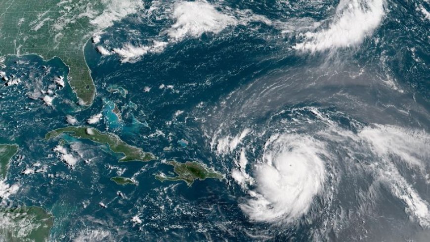
Sunday, August 17, 2025 — The Atlantic hurricane season reached a new level of intensity this weekend as Hurricane Erin rapidly strengthened into a Category 5 storm near the Caribbean. With maximum sustained winds now topping 160 mph (257 km/h), the storm became one of the most powerful systems of the 2025 season.
Although Erin is not currently forecast to make direct landfall, its outer bands have already begun lashing nearby islands, triggering warnings of coastal flooding, heavy rainfall, and possible landslides.
Rapid Intensification Stuns Forecasters
Meteorologists tracking the storm noted Erin’s sudden escalation in strength between Saturday, August 16, and Sunday, August 17, 2025. Within just 24 hours, the hurricane grew from a Category 2 to a Category 5, making it one of the fastest intensifying storms of the last decade.
According to the National Hurricane Center (NHC), Erin was located east of the northern Leeward Islands early Sunday morning, moving northwest at a steady pace. While the core of the hurricane is expected to remain offshore, its size and strength mean hurricane-force winds extend more than 45 miles from the center, with tropical-storm-force winds stretching over 150 miles outward.
Forecasters emphasize that even without a direct strike, nearby islands remain at risk of serious hazards.
Islands Brace for Impact
Authorities in Puerto Rico, the U.S. Virgin Islands, and parts of the Lesser Antilles issued flood and landslide alerts as bands of torrential rain swept across the region on Sunday afternoon. Local officials have urged residents in flood-prone zones to move to higher ground and prepare for possible power outages.
“This is a dangerous storm, even if it stays offshore,” said one emergency management official in San Juan on Sunday. “Heavy rainfall and storm surge can create life-threatening conditions quickly.”
The Dominican Republic and Haiti have also issued weather watches, although the storm’s projected path suggests it will keep a safe distance from Hispaniola. Still, forecasters caution that a slight shift westward could change the outlook.
Comparisons to Past Hurricanes
Erin’s explosive growth has already drawn comparisons to historic storms like Hurricane Irma in 2017, which devastated several Caribbean islands. The rapid intensification highlights the challenges scientists face in predicting how warm ocean waters fuel storms in an era of changing climate.
The Atlantic has seen above-average sea surface temperatures this year, a factor that experts believe helped fuel Erin’s sudden surge to Category 5 strength. As noted by climate scientists, warmer oceans act as high-octane fuel for tropical systems, enabling them to intensify at alarming speeds.
Forecast Track and Next Steps
As of Sunday evening, models suggest Erin will continue on a northwest trajectory through early next week, between Monday, August 18, and Wednesday, August 20, 2025, gradually curving into the open Atlantic. If the storm maintains its path, the Bahamas and U.S. East Coast are not expected to face direct landfall, but forecasters will monitor its progress closely.
The National Hurricane Center continues to issue advisories every six hours, urging residents across the Caribbean basin and southeastern United States to stay alert in case the forecast track shifts. Updates can be followed on the National Hurricane Center website.
Meanwhile, detailed coverage and live updates are also being provided by Weather.com, where meteorologists are tracking rainfall predictions, surge risks, and storm path projections.
Human Toll of Uncertainty
For many Caribbean residents, even the threat of a storm of this magnitude is enough to stir painful memories of past disasters. In towns still recovering from earlier hurricane seasons, preparations are already underway. Businesses are boarding up, schools are closing as a precaution, and relief organizations are standing by in case rapid response aid becomes necessary.
Local weather experts have warned that mudslides could become a major concern in mountainous regions of Puerto Rico and Dominica, where rainfall totals may reach 8 to 12 inches by late Monday.
Final Outlook
While Hurricane Erin may ultimately stay out at sea, its Category 5 strength serves as a stark reminder of the Atlantic’s growing volatility during peak hurricane season. Residents across the Caribbean are being urged to remain vigilant as officials continue to monitor the storm’s trajectory in the coming days.
For now, Erin’s most dangerous impacts are heavy rainfall, flooding, and strong winds felt far from its eye — a sobering reminder that a hurricane doesn’t need to make landfall to leave its mark.