New Atlantic Wake-Up Call: Invest 97L Forms off Africa as 96L Fades
As Invest 96L drifts into the Atlantic, forecasters are watching a new tropical wave off Africa—Invest 97L—with development chances up to 40%. It could reach the Caribbean as early as mid-August.
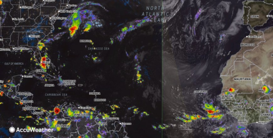
As Invest 96L drifts benignly into the open Atlantic, forecasters have turned their attention to a fresh tropical wave emerging off the western coast of Africa. Just designated as Invest 97L, this nascent system has already seen its development probability doubled over the last week—raising watchfulness over potential impacts in the Caribbean as early as mid-August.
Invest 96L Slows to a Whisper
Named earlier in the week after forming in the Main Development Region, Invest 96L had raised hopes of becoming a named storm—possibly Tropical Storm Erin. However, it has struggled against dry Saharan air and now appears destined to steer harmlessly northward into open waters, posing minimal threat to land.Houston ChronicleFOX Weather
Invest 97L: A New Concern Arises
Meanwhile, a new tropical disturbance—Invest 97L—has emerged just off Africa’s coast. The National Hurricane Center (NHC) has already upgraded the system’s development odds from low (around 20%) to medium (about 40%) over the next seven days.FOX Weather+1
This wave is traversing a more favorable track, positioned further south than 96L and avoiding the dusty air that stifled its predecessor. Forecast models suggest it could develop into a tropical depression by mid-week, as it continues west-northwest across the favorable eastern and central tropical Atlantic.FOX WeatherThe Weather Channel
Conditions Could Favor Extension Into the Caribbean
The wave is expected to cross over the Cape Verde Islands into the tropical Atlantic by early next week. As it approaches the.
warm waters of the western Atlantic and Caribbean, atmospheric conditions are forecast to become increasingly favorable for development, potentially forming into a tropical storm shortly thereafter.The Weather ChannelWKMG
Some model guidance positions the system near the Lesser Antilles or northeastern Caribbean by next Friday or Saturday—though it’s too soon to predict intensification or precise tracks.The Weather ChannelWKMG
Why This Matters: The Active Heart of Hurricane Season
The Atlantic hurricane season peaks around September 10, but climatologically significant activity—including Cape Verde–type storms—can begin building by mid-August.
Meteorological shifts, like the Madden–Julian Oscillation (MJO), are currently enhancing moisture and upward motion in the tropical Atlantic—classic precursors for storm genesis.WKMG
This emerging wave, Invest 97L, may be the first of several disturbances rolling off Africa in the coming weeks. With each carrying the potential for east-to-west movement, the Caribbean, U.S., and even Bermuda may need to start paying attention.FOX WeatherWKMG
What Forecasters Warn
Despite early development indicators, long-range forecasts—including social media speculation—may be misleadingly speculative. Meteorologists caution against over-interpreting distant model runs, especially beyond the 7–10 day window where uncertainties climb dramatically.FOX WeatherWKMG
Still, organizations like Fox Weather’s Bryan Norcross emphasize the importance of monitoring these early systems, even as formal forecasts refine over the coming week.FOX WeatherThe Weather Channel
Conclusion
With 96L fading, Invest 97L steps into the spotlight—its development potential significantly raised, and its trajectory hinting at Caribbean interest as early as mid-August. While too early to predict outcomes, the Atlantic is clearly awakening from its early-season slumber, reminding us that hurricane season is a marathon, not a sprint.
For now, Caribbean and Atlantic-border regions should stay alert, even as forecasters work to parse tomorrow’s possibilities—and the tropics continue to churn on.